A Watershed Partnership
The Lampasas River Watershed Partnership, a collaboration of local citizens, cities, counties, and state and federal agencies, was formed to restore and protect water quality in the Lampasas River. The Partnership completed a Watershed Protection Plan (WPP) in 2013. The WPP identifies potential sources of pollution and provides a basic strategy to restore and protect water quality in the Lampasas River and its tributaries. The plan received EPA approval in September 2013. The Partnership has worked with various local, state and federal entities to implement the components of the WPP since acceptance. A copy of the WPP can be downloaded from www.lampasasriver.org.
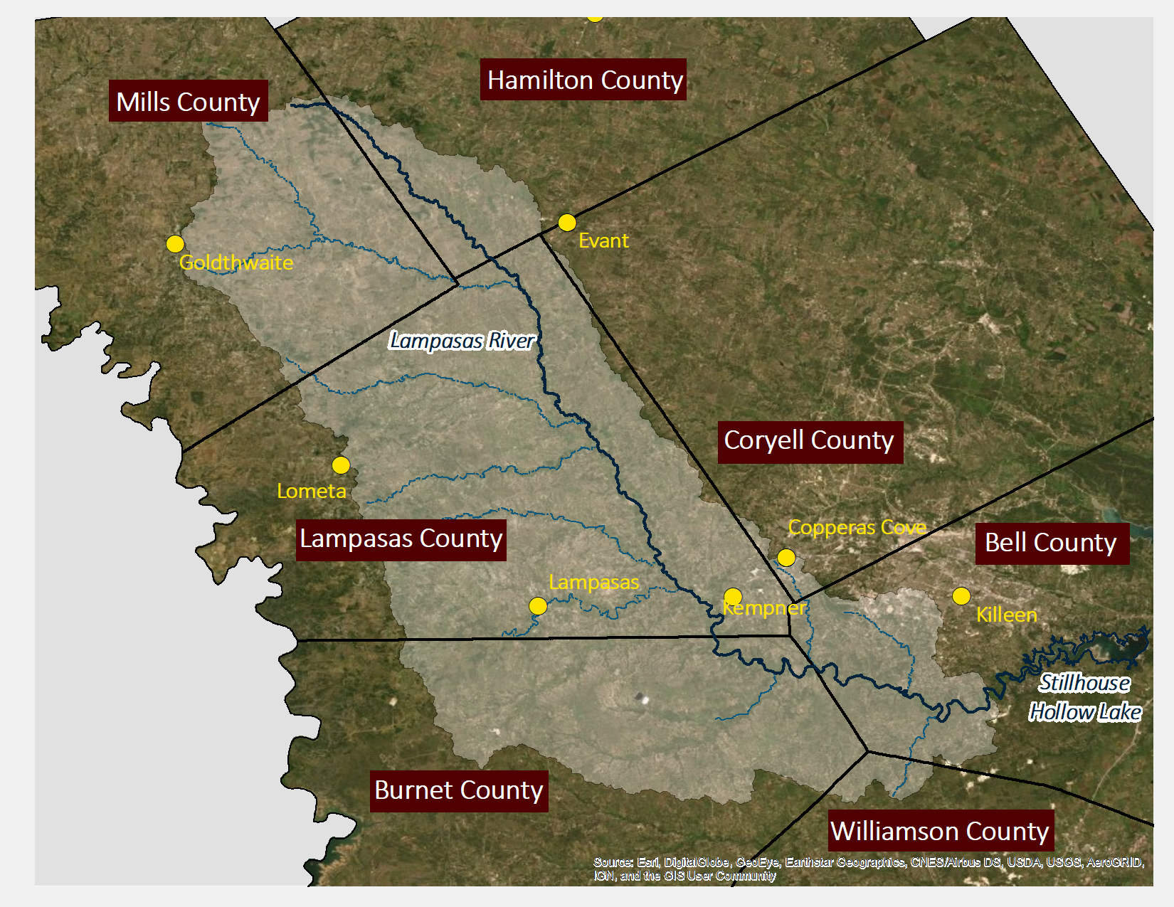
The Lampasas River
The Lampasas River begins in eastern Mills County and flows southeast for 75 miles before it is dammed 5 miles southwest of Belton to form Stillhouse Hollow Lake. The approximately 1,250 square mile Lampasas River watershed lies within the larger Brazos River Basin. The watershed is primarily rural with few urban areas which include the city limits of Lampasas and portions of the city limits of both Copperas Cove and Killeen along with a portion of Fort Hood Military Reservation. Other small communities of Adamsville, Star, Kempner and Oakalla are also located in the watershed. Although the population in the northern region of the watershed remains stable, the areas in the southern region are rapidly developing and transitioning from rural to urban landscapes. As development and population growth continues, the portion of urbanized land will grow and play an increasingly important role in the hydrology and water quality of Lampasas River and its tributaries.
Water Quality Concerns
Current Implementation Overview
- Technical and financial assistance for implementation of conservation practices on agricultural land through cooperation with Hill Country Soil & Water Conservation District (SWCD) #534
- On-Site Sewage Facility (OSSF) Inventory and Repair/Replacement Program
- Coordinate education and outreach measures outlined in the WPP
- Collect water quality data to measure trends and changes in water quality
Conservation Practices on Ag Lands
The Hill Country SWCD, working with state and federal agencies, have provided technical and financial assistance to agricultural producers in the Lampasas River watershed through several Clean Water Act (CWA) Section 319 grants from the TSSWCB and the U.S. EPA. The District Technician worked with local producers to develop Water Quality Management Program (WQMP) that address each producer's specific operational goals. Implementation of WQMPs will continue to be a key component in the efforts to improve water quality in the Lampasas River watershed. For more information about this program, please call (512) 556-5572, extension 3.
Addressing Failing Septic Systems
Texas A&M AgriLife Extension received funding through a CWA Section 319 grant to fund the repair or replacement of septic systems in the Lampasas River watershed in an effort to improve water quality in the Lampasas River and its tributaries. Failing OSSFs have been identified as potential sources of pollution in the Lampasas River WPP. Funding is now available to repair or replace approximately 20 systems within the watershed. This program has also hosted virtual informational clinics to allow homeowners opportunities to learn more about their systems. For more information about this program, please call (254) 774-6008.
Facilitation, Education and Outreach
Texas A&M AgriLife Research continues to engage and facilitate the Partnership with funding through CWA Section 319 grants. AgriLife Research provides general oversight, coordination of all project activities, and manages project reporting through the position of a Watershed Coordinator. The Watershed Coordinator serves as the primary conduit for interaction with landowners, citizens, and entities to facilitate the implementation of the WPP. The Watershed Coordinator also conducts water resources and related environmental outreach/education efforts across the watershed, as identified in the Lampasas River WPP.
Funding and support for these efforts are provided through Clean Water Act §319(h) Nonpoint Source Grants from the Texas State Soil and Water Conservation Board, the Texas Commission on Environmental Quality, and the U.S. Environmental Protection Agency.